The Folded Route: Why a Paper Map Still Makes a Brilliant Sunday Ride
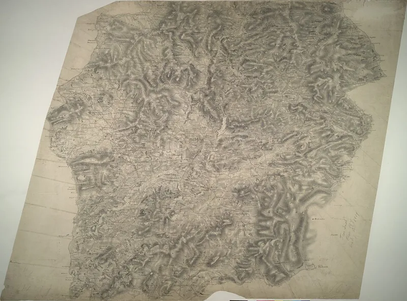
Photo: [Budgen, Thomas] - Draughtsman, OGL v1.0, via Wikimedia Commons
There is a moment, usually on a Friday evening, when the phone gives up. The route file has loaded, the elevation profile looks suitably alarming, and then the battery indicator quietly reminds you that it has been a long week. This is not a disaster. It is an invitation to do things the slow way.
A paper map will not ping, dim or demand a software update. It will not reroute you into a dual carriageway because the algorithm has had a funny turn. Folded across the kitchen table, it offers something better than turn-by-turn instructions: a picture of where you actually are.
Start with the postcode, not the perfect route
Begin at home. Not metaphorically — literally. Find your postcode on an Ordnance Survey Explorer map if you can, or a Landranger if you want a broader view. Explorer maps show more detail, which matters when you are trying to work out whether that promising line is a bridleway or a footpath you should not be riding.
Mark your front door with a pencil. Then draw a rough circle around it at the distance you fancy: twenty miles, thirty, forty. The circle is not a target. It is a boundary. It stops the ride from becoming an expedition and keeps the return leg within reach of tired legs and fading light.
From there, look for the squiggly stuff. Quiet lanes, contour lines that suggest a gentle roll rather than a wall, and green dashed lines that mean bridleways. In England and Wales, bridleways are generally open to cyclists, but footpaths are not. In Scotland, access rules are different and generally more generous, but local signage still matters. If in doubt, check the key and ask someone who knows the area.
Read the map like a rider, not a sat-nav
A paper map rewards a certain kind of curiosity. You start noticing things a route file hides: the church spire that gives you a landmark for the last ten miles, the woodland edge that might offer shelter from a headwind, the tiny loop of road that avoids a busy junction.
Look at the contour lines. They are not there to frighten you. They tell you where the climbing sits and whether it comes in one lump or several short, sharp digs. If the map shows a cluster of chevrons on a lane, you have found a steep bit. That is useful information, not a reason to panic.
Then look at the crossings. A route can be lovely on either side of an A-road and thoroughly unpleasant in the middle. Study the junctions. Is there a bridge, a roundabout, a village with a speed limit and a pavement? Would you be happy riding it at ten in the morning on a Sunday? If not, find another way round. A mile of detour is cheap. A sketchy crossing is not.
Build in somewhere to stop
The best weekend loops are not just lines on a map. They have a punctuation mark in the middle: a café, a village shop, a pub that does a decent pot of tea. Put that stop on the map before you finalise the route. It gives the ride a shape and gives you something to look forward to when the headwind turns.
Use the map to find villages with a shop or a hall. Check the opening times before you go — rural hours can be gloriously eccentric. If you are relying on a café, it is worth a quick look online or a phone call. If you are packing your own flask and sandwiches, find a bench or a green with a decent view and make that the destination instead.
The stop also gives you a natural place to check the map again. Fold it to the relevant section, not the whole sheet. A map folded properly is a thing of beauty. A map flapping in the wind is a sail. Keep it in a bar bag or a jacket pocket, ideally in a clear case if the forecast is moody.
Plan for the phone to die
This is not an anti-technology article. A GPS unit or phone is a useful backup, especially if the weather turns or you miss a turning. But the paper map should be the primary plan, not the emergency plan. That way, a flat battery is an inconvenience rather than a crisis.
Before you leave, write down the key turns on a piece of tape or a small card. Not every junction — just the ones that matter: the turn after the bridge, the lane opposite the pub, the left at the crossroads. It sounds old-fashioned because it is. It also works.
Tell someone where you are going and when you expect to be back. Take a pump, a tube, a multitool and a bit of food. Charge your phone, but do not rely on it. The map does not need a signal, and neither does the café.
The point is not to suffer
Riding without a downloaded route can feel strange at first. You may miss a turn. You may end up on a lane that looks promising on paper and turns out to be a bit more gravel than expected. That is part of it. The ride is not a test of map-reading precision. It is a way of paying attention to where you live.
Familiar ground becomes new when you have to look at it properly. The lane you have driven past a hundred times suddenly has a name and a direction. The hill you avoid in the car becomes a gentle climb on a Sunday morning. The village you thought was just a signpost turns out to have a shop, a bench and a very good flapjack.
So fold the map, pick a postcode, and give yourself a few hours. No screen, no route file, no pressure. Just lanes, landmarks and a bit of curiosity. The battery can die. The ride does not have to.